Roads Norwegian Style
- thepadol2
- Jan 29, 2023
- 9 min read

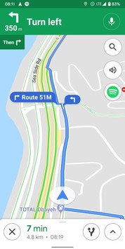
A navigator used to be a person, maybe someone who was in the back seat. Today the digital equivalent has become our navigator to be trusted, even blindly by many. There's no denying that Google Maps is capable of creating a usable routing and in real time can identify alternatives based on traffic conditions. Although there are options for some parameter customization, Google Maps will basically give you the most efficient routing to go from A to B.


Therein lies an insidious problem depending on where you want to go and what you expect. If time is of essence and you could care less of the actual types of roads used, then Google Maps' route is a good bet. In a country like Norway, there are few superhighways as in two lanes each way, and major roads are single lanes at best. Secondary roads are tight single lanes although with little traffic. Secondary roads may pass thru villages and may occasional pass a gas station although far and few between. Mountain secondary roads may be closed t due to seasonal weather conditions or due to falling rocks. They are also particularly tight and in some cases passing is not possible because of the narrow width, someone needs to reverse to nearest widest point. On steep climbs and descents speed will be considerably impacted.
The route provided by Google Maps as a real time navigator does not show what type of roads you will be on or are currently on. As you zoom in and out it merely shows waypoints in more detail and more names of cities and villages in proximity popup. Still if you are not familiar with the area, you will not be able to determine whether it is merely a village with 10 homes or city with 10,000 souls. Google Maps is unidimensional in this regard.

Old style navigation in the analogue days was the road atlas map. Maps for road travel used an almost standardized communication palette. Main arteries are generally thicker lines and bold color. Secondary roads use progressively lighter color and thinner lines. The same with cities and villages. At a glance you could see where the main roads are and where there are alternatives to use a secondary road to shorten distances but perhaps not in terms of time if the road means using challenging mountain passes or slower speeds. Printed maps have a limitation to the level of granularity that they can show so dirt roads, say the ox cart path, are not included. Google Maps on the other hand seems to care less whether the user should be made aware.
So if you take an itinerary suggested by Google Maps and you see the name of a city on the route that doesn't look familiar try to reference it on a printed map. Perhaps you might find it and it really is on a secondary road that you might want to consider avoiding. Worse, you might not even be able to find it which means it really is small and not useful on a printed map resolution.
Would you trust Google Maps or any other digital navigator app blindly? No. If it is an area that you are unfamiliar and you can do some preplanning, take out a printed map or find one on the internet and see if you are able to cross reference easily. Make a more complete decision. Many, never having navigated the old way, hardly have a sense of direction or even the layout of interesting cities on a possible direction and distance.
Scenic but demanding roads

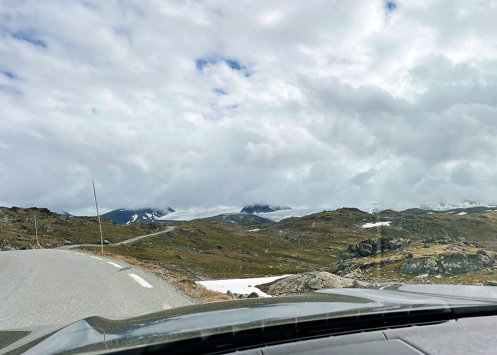
Norway, the land of fjords, glacier, and mountains, has one more characteristic that makes it a real challenge for any road trip - it's basically a narrow and very very long country with distances beyond 3000 km end to end. Most of the main roads are basic one lane highways with speed limits at 70 kph.

To visitors, Norway's driving characteristic is much more visible and perceptible than in other European countries. The road rule of right of way is particularly insidious whether you are coming from the USA or Italy, leaving out for the moment those who come from countries that are right hand drive who already start out handicapped. The rule is quite simple as stated. Bearing no other indications, traffic is yielded to those arriving from the right. Any basic driving education covers this with common depictions of intersections. When expanding and extending this to scenarios in other road conditions, countries vary. Most European countries and the US have explicit road signs so that motorists are given the applicable rule of the road. As you come to an intersection you will see appropriate markings as to whether you must yield or stop. Europe differs from the US as there is also a priority road sign (diamond marker) to tell motorists that the road they are travelling on is a priority road and therefore intersecting traffic will yield and stop.
Yield - How hard can that be?


Norway geographically covers quite a bit of land while population density outside of the main cities is very low. Consequently motor vehicles are mainly in the large cities. Norway therefore uses the rule for right of way thoroughly and is applied as the rule rather than road signs. Imagine this then. Outside of city limits, highways and main roads will have the priority road sign if that is the case. Upon entering the city limits roadways that turn into city streets will have a no priority road sign to indicate that priority is terminated. Noting this sign is extemely important and crucial. Beyond that point the right of way rule must be followed scrupulously. Intersections will be encountered, some with other streets, others may be small streets, alley-like. In the absence of any further road signs, all must be treated as potential right of way encounters. OK so the rule stated is understood, but how to behave? Norwegian drivers are taught as follows. In city limits proceed with caution. Beware of upcoming pedestrain crossings and possible intersections. If there is a pedestrian in the vicinity of the crossing and even should they be stationary, you must slow down to stop before the crossing as the pedestrian has a right of way. As you come to an intersection you must slow down sufficiently to see a vehicle approaching from the right and if so to determine if you can proceed safely or yield for right of way. Some would ask if that determination is subjective. A local Norwegian once explained:
"The way to think is if you were driving in place of the other person. As you approach the intersection you would look right for vehicles that you have to yield to. You look left and front for other vehicles that should yield to you. If any vehicle from these directions move into your pathway, and you must slow down or even apply your brakes, then by causing you take an action, they have not respected the right of way rule."
So when driving in ctiy limits, speed limits of 50 kph are almost like wishful thinking since one will always have to slow down and stop due to the numerous insteresction and possible traffic.

EV paradise?


Norway is the leading country in Europe for EV dominance. Just about everywhere you look, it's an EV. In 2022 the number of Teslas, S and 3s, was surprising, even far from city centers. The number of supercharger station is high with a good coverage. Other network and providers provide quite a good capillary coverage. But it is Tesla that has the best and seamless experience. On the country roads a Tesla isn't just a Tesla - many Tesla 3s have a rear hitch carrier. Never asked the reasons why but presume it has to do with the remoteness and the need to carry additional goods over a distance. Tesla Supercharger stations have consequently adapted by providing some charge stalls that are are double in length to accommodate the rear cargo hitch. That's called being consumer and market aware.
Narrow roads
Most of the roads are well maintained and are also promptly repaired due to the harsh winter conditions and ever present rocks and land slides. While considered highways, the major roads outside of Oslo are really like secondary roads.

They range from undivided highways with single lanes to single track road with designated passing points. The latter is far more common the further you go from city center. Visitors unfamiliar with these single track roads don't really know how to handle them very well, posing a risk to others as well as to themselves.
Single track roads
The road width ranges for one and half car width to just one truck width. This width is denoted by dashed lines on the side. Between the inside the left and right dash lines is the usable lane or track. To the outside is a rather narrow width of asphalt, generally sloping to facilitate water drenage. It is not considered a usable road shoulder. In most cases the single track road is higher than the surrounding land, so if go over the dashed lines, the risk of simply rolling over the side of the road is more than real. In rain or wet conditions this risk is even higher. Designated passing spots are provided and usable intervals and if you drive within the posted speed limits you should be able to judge oncoming traffic and who stops first to let the other pass.

Mountain pass single track roads pose an additional challenge. These road wind and wrap around the mountain and when covered by trees, it isn't easy to see oncoming traffic making impassable situations. The rule is for the vehicle going up to reverse to the nearest passing spot.
Quasi single track roads

Nothing is ever absolutely precise. There are many roads that are marked as single track but the width is nearly that of an undivided highway, just falls short of the official standard. Being formally single track they should be driven as such - use caution to determine passing. Many visitors use personal judgement and see that the road looks "wide" tend to proceed at normal speed and on oncoming traffic simply move to the side to provide clearance. In theory this works but in practice it is extremely risky. Both parties must exercise caution which really means slowing down to better judge the passing space and if use of the side small shoulder is required, to possibly slow down to almost stopping for safety.

Gas stations
If with a gasoline car, one needs to be conscious that outside of populated areas, gas stations become far and few between. In some cases over 100 km to the next station and if in mountainous areas, gas consumption will also go up accordingly. Never go below half tank is probably a wise choice. Gas pumps can also be very basic in the less dense areas. Just the pump and a credit card reader. No attendant and no place in sight. Even if there is a a small store at the pump it is likely that it has no relation to the pump provider, they just happen to be in the same spot.
Ferries

A country of fjords and waterways makes ferries a way of life when driving. Most time the alternative to a 20 minute crossing is to take the long way around and in some cases could be over 6 hours. During the summer ferries run regularly and are less prone to vagaries of the weather. In the winter and when snow is present, one isn't so lucky. Charges for ferries are automatic via license plate recognition. You must be registered or equipped with the appropriate sensor for recognition. For popular ferry crossings the summer months can be challenging. People who are touring in camper vans simply queue up the night before and next day will make the first and perhaps only crossing available. Doesn't sound fair and it isn't, but that's why a road trip in Norway requires extensive planning and with good plan b for backup.

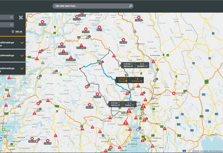
A critical part of Norwegian driving is the vegvesen.no website which is a true lifesaver as it provides all the crucial status information of roads in real-time. Any interruption are notified in real time. All planned and ongoing roadworks are clearly identified including hours when traffic is partially permitted. Road closure can occur at any time due to weather conditions not suitable for the particular road. So if it says a section of road is closed it means exactly that.
Scenery
As visitor, the other side of the coin is the breathtaking scenery which really includes any type imaginable, from lush green to mars like views, and anything in between. Most people who do not plan properly simply do not get it that if the distance is 100 km you have to plan as if it were 200 km because you are doing 50 kph instead of 100 kph, and that it will be even more if you intend to stop and take pictures at multiple locations. Due to the geography, most places people would like to go are not connected by train and while buses run, the timing isn't the greatest. Many rent a camper van because Norway is camping friendly albeit with some rules to comply with strictly.

Summer Collection

As the seasons change, the snow disappears, and the sun shines forever longer in the day, Norwegian owners of classic cars open the garage to let their collections stretch their legs and get some tan, no pun intended. Vintage Volvos and Saabs abound as to be expected, but even American classics of all eras are to be noted as well.
Driving in Norway in winter conditions is a different ball game..........even the Norwegians are frustrated with other Norwegians who do not take the proper care for snow and ice driving.


Wow! Single track indeed! BTW, I had similar Google maps negative experience in Italy recently. Took me into some of the narrowest alleyways in Cagliari! Stressful. :-)